Remote sensing / Earth observation
Remote sensing is a technology used to collect information about the Earth's surface from a distance, typically using satellites equipped with advanced sensors. These sensors capture data by detecting the reflected or emitted radiation from the Earth's surface across various wavelengths, including visible light, infrared, and radar. Leveraging our huge collection of archived imagery or new tasking acquisition, SCT acts as a one-stop shop for all your needs.
Remote sensing is a technology used to collect information about the Earth's surface from a distance, typically using satellites equipped with advanced sensors. These sensors capture data by detecting the reflected or emitted radiation from the Earth's surface across various wavelengths. Satellite imagery can cover vast areas of the Earth’s surface, including remote areas, which could help in cost reduction and reduce the field of work (cost-effective). Furthermore, satellite imagery provides consistent data that can give insights usually overlooked and builds an archive of imagery and data which prove to be helpful in current and future studies & applications.
Why do we use Remote Sensing?
- Cover large areas
- Time efficiency
- Rapid data collection
- Capture data in various wavelengths (including data not visible to the human eye)
- Cost-effective
- No manpower required
- Instantaneous data that’s easy to track
Remote sensing verticals
- Land use / land cover
- Urban planning / infrastructure monitoring
- Agriculture (Crop health, soil properties/moisture, to optimize agri. practices)
- Change detection
- Oil & Gas (Pipeline monitoring, oil leaks, site monitoring, environmental monitoring)
- Mining (Detection, site monitoring, environmental compliance)
- Maritime (vessel detection and port management)
- Marine: Marine and coastal management (beach/coastal erosion, mangrove trees, biodiversity)
- Environmental (water quality / water pollution / oil spill detection)
- Disaster management (natural disaster / disaster recovery)
- Defense & Intelligence (Surveillance, border monitoring, assessing military operations, strategic planning)
Imagery resolutions available/ products
Resolution refers to the level of detail that an image can capture and display. It’s determined by the smallest object or feature that can be clearly distinguished in the image.
Resolutions available:
- 0.3 m
- 0.5 m
- 1 m
- 5 m
- 10 m
- 22 m and more
Sensor types:
-
- Optical
optical imagery refers to images of the Earth's surface that are captured using sensors on satellites, which detect and record visible light and sometimes near-infrared light. These sensors work like very powerful cameras, taking detailed pictures of the Earth from space.
-
- SAR
Synthetic Aperture Radar (SAR) is a type of radar system used to create detailed images of the Earth's surface. Unlike regular cameras, which rely on visible light, SAR uses radio waves to "see" the ground, even in the dark or through cloud.
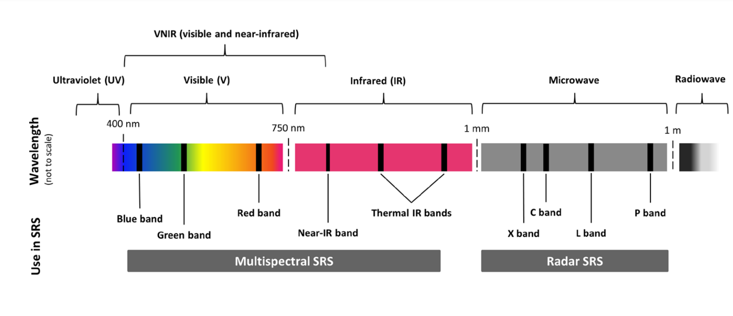
Spectral bands:
A spectral band refers to a specific range of
wavelengths in the electromagnetic spectrum that a satellite sensor can detect. Different spectral bands correspond to different types of electromagnetic radiation, such as visible light, infrared, or ultraviolet. Each band captures specific information about the Earth's surface or atmosphere, depending on the wavelengths it covers.
- Panchromatic
- Infrared (IR)
- Near Infrared (NIR)
- Short wave infrared (SWIR)
- Multi-spectral
- Hyperspectral
- VNIR (Very Near Infrared)
Imagery analysis (Local & International)
- Digital Terrain Model (DTM), Digital Surface Model (DSM), Digital Elevation Model (DEM)
- 3D models
- Image analysis (for all vectors)
OUR OFFICIAL PARTNERS
With international partners around the globe and local partners, SCT acts as a one-stop shop for all your satellite imagery and analysis needs.